History of the Corinna goldfields
Gold was known in the northwest of Tasmania since at least the 1850s, when James (Philosopher) Smith discovered some in the Forth Valley near the modern-day Lake Cethana dam. Some minor rushes developed, and locations included the Hellyer River, the Cam, Calder, Arthur, Inglis and Forth Rivers. These and many of their tributaries were worked as early as the 1860s. However none of the workings were on a large scale.
Despite the widespread finds of quantities of gold throughout the northwest, the country to the west of Hampshire was still remote, and largely unexplored. James Smith’s discovery of the Mt Bischoff tin deposit near modern-day Waratah in the early 1870s stimulated mineral exploration in the area. By the end of 1876, Charles Sprent had carried out two exploration trips in the area. He reported finding gold, tin or osmiridium in almost every creek and river system. He urged the authorities to open up the area and encourage prospecting.

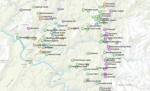
Corinna goldfield. Green icons are alluvial gold workings. Photo courtesy of MRTmap.
Widespread prospecting had also located the Heemskirk tin field, west of Zeehan, in 1876. It was only a matter of time until the country to the north was properly prospected. A Heemskirk miner, Jack Brown, heard rumours of gold between Waratah and Corinna and set off to prospect. He made the first important discovery in the area now known as Brown Plains, named after him. Not long after, Harry Middleton also heard rumours or news of the discoveries. He went prospecting up the Whyte and Savage rivers, and discovered the first deposit of payable gold on the west coast of Tasmania: Middleton Creek, near Corinna. The find was rich and word soon spread out. The history of the Corinna gold field kicked off with a rush. Within months as many as 400 men were working all along its length.
Middleton Creek had a relatively small catchment, and its deposit was shallow. It soon gave out. Prospectors fanned out, eventually finding payable deposits in many of the creeks running into the Savage, Donaldson and Whyte rivers.
Stagnation and revival
By the late 1880s, all the deposits that could be easily worked by prospectors were exhausted. The Corinna goldfield was all but abandoned, as the focus shifted to more profitable hard-rock mining in other parts of the State. The advent of hydraulic sluicing, or hydraulicking, saw a revival. Companies were formed in 1894-1895 to work the large-scale deposits that weren’t rich enough to pay using conventional methods:
- The Corinna Hydraulic Gold Mining company,
- The Donaldson Hydraulic Gold Mining Company,
- The New Donaldson Hydraulic Gold Mining Company,
- The Lucy Spur Hydraulic Gold Mining Company,
- The Brookside Hydraulic Gold Mining Company,
- The Brooklyn Hydraulic Gold Mining Company, and
- The Paradise Creek Hydraulic Gold Mining Company,
It turns out the deposits were still not quite rich enough to work profitably. The companies formed to work them quickly went bankrupt, and by the end of 1896 the Great Corinna Hydraulic Mining Experiment (I just made the name up, BTW) had come to an end. Some companies never even had the chance to test their grounds. Shareholders were so despondent that they folded them up before carrying out any proper testing. Sporadic revivals of small scale prospecting and mining companies occurred until about the start of World War II.
Exploration and mining in Corinna today

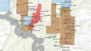
Current (2015) mineral tenements in Corinna. Photo courtesy of MRTmap.
There are two mines in the Corinna area today: The Grange Resources Savage River iron ore mine, and the Cominex silica mine (red hashing in the picture to the right). In addition there are two noteworthy exploration licence areas: Middleton Creek area and the northern end of Brown Plains, a.k.a. the Pistol Range prospect (both hashed in blue). Access to the leases for any reason will need permission from the tenement holders. Access to the exploration licence areas for prospecting requires permission as well, but no permission is needed for general access. There are several Exploration Release Areas (ERAs, brown) that are fair game, no permissions required. There is a caveat for the ERAs, as some of them overlap reserve types that are not available to prospecting (see below)
The area of the Pieman River State Reserve (greyed out) is totally out of bounds to prospecting and fossicking.

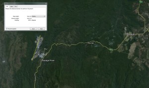
The Corinna area is home to the Savage River iron ore mine. It is 8 km long and 4 km wide. Photo courtesy of Google Earth.
Caveat: Some of the area around Mount Donaldson is classed as a Nature Recreation Area, so excluded from prospecting under current prospecting rules (2015). Large-scale, moonscape-inducing, mega-tonnage mining (see picture on the left) is allowed and even encouraged in this reserve type, and part of it is currently being promoted to mining companies as an ERA. However, if you take your family to pan for gold in one of the creeks that have been mined historically as many as six or seven times, you’ll be breaking the law. Your licence can be revoked and you’ll be up for a possible $15,400 fine if you prospect without it, so beware. It seems like the regulators at Mineral Resources Tasmania are afraid that small-scale prospectors, as they pan and detect around the area will do more damage than large-scale industrial mining. For a point of comparison, the nearby Savage River Mine (in the photo above) is a crater in the ground 8 km long by 4 km wide. Go figure.
It may be possible to obtain a permit from Parks and Wildlife to prospect in Nature Recreation Areas, but a prospecting licence does not allow it. Careful reading of the definitions of fossicking and prospecting in the Mineral Resources Development Act (as it stands in 2015) might also reveal that what you’re doing is actually fossicking, rather than prospecting, and not subject to the same restrictions.
Where to go
Unlike many areas in the northeast of Tasmania (Mathinna, Mangana, Lefroy, Back Creek), there is plenty of available area for prospecting where good gold was found historically.
Large to very large nuggets have been found in the Rocky River area. The Paradise River (and Creek) were quite productive back in the day, but notoriously patchy, and I haven’t had much luck there. The Savage River is reputedly still quite good if you find a good patch. There are plenty of small creeks draining the north and south of Brown Plains and the spurs above Corinna that are probably worth a go, but be mindful of the State Reserve.
Since the field was mostly alluvial and worked by prospectors, there were very few records of yields kept, and a lot of the knowledge of good areas is probably lost.
Other than gold, you’ll often come across osmiridium in the Corinna area. It becomes much more common in the upper Savage River and Nineteen Mile Creek area, where it was mined in the early part of the 20th Century. The Corinna goldfield was also renowned as the main location in Tasmania where diamonds have been found.
Now that we’ve hit spring and the weather (and the water) is starting to get warmer, it’s time to get out there!
Did you find this useful? If you like the content at Apple Isle Prospector, feel free to get in contact, or leave a comment. If you enjoyed this article, then let others know by sharing it on Facebook or liking our Facebook or Twitter pages:


Nice post, both Kel and I enjoyed our brief visit to the Corinna area awhile back. We would be keen to go back and spend more time in the area at some stage, just sayin. 😉
Thanks! It’s a beautiful area, I wish it wasn’t so far from Hobart!
Again another excellent read Miguel, I live in the north west and am keen to have a look around in the Corinna area sometime. It looks like there is quite a large area available with old gold diggings scattered throughout, we have both the 5000 and SDC is there anywhere clear enough to swing coil?
Thanks John,
There are a lot of historical workings in the area. Most of the workings away from creeks are scrubby and overgrown, but the creeks and rivers can be good. Middleton Creek Exploration Licence has just been given up, and it’s quite clear, but well picked over. Still, I managed to find some gold there last time. Summer and autumn when the water level’s low is the best time to go. I’d also try any of the historical workings. Look for mullock heaps.
Good luck!
Thanks mate for the info , we will let you know how things go.
Gday where is exactly is the ‘rocky river’? Would love to have a go there but can’t find any Google reference
Hi Zac, the Rocky River comes into the Whyte River, near Corinna, in NW Tasmania.